

It's February, and thousands of hikers are preparing to attempt a thru-hike of the Appalachian Trail and other long distance hiking trails. Maybe you wish you could be one of them, but you don’t have that much time or ambition. How does a one-week thru-hike right here in Northern Virginia sound? Let me introduce the Massanutten Trail, a 71-mile loop trail that is just west of Front Royal and a little over an hour from Good Wolf Gear. I recommended the area as an alternative to Shenandoah for fall color, but it’s ready for your one-week thru-hike adventure.
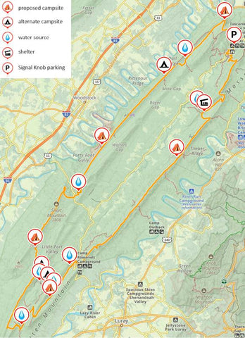
Massanutten Mountain runs southwest to northeast between the meandering North and South Forks of the Shenandoah, and I was immediately intrigued when I first saw it from the air a decade ago. The Potomac Appalachian Trail Club (PATC) maintains the trail and offers Map G and a Guide to Massanutten Mountain Hiking Trails, both of which are indispensable for planning. Some northern parts of the trail are coincident with the blue-blazed Tuscarora Trail, which was originally constructed as a reroute of the Appalachian Trail. The northern and eastern parts of the trail have many fine campsites, excellent water sources, and even a couple developed campgrounds at Elizabeth Furnace and Camp Roosevelt. The ridges on the western side have limited campsites and water, so careful planning and flexibility are important.
Here's a proposed itinerary I’ve developed based on the 3 backpacking trips I made to Massanutten Mountain in 2023.
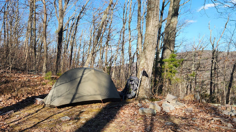
Day 1: Signal Knob parking to Milford Gap (approx. 13 miles). Start this clockwise loop from the trailhead at the south end of the parking lot. The Elizabeth Furnace historic site provides some interest early on after you pass the Elizabeth Furnace campground, where you might stay for a night before or after your trip. For much of the day, the trail will be coincident with the Tuscarora Trail, and you’ll pass the AT-style Little Crease Shelter, where you’ll need to load up with water before you ascend to a large, but dry ridgetop campsite at Milford Gap. You’ll be rewarded with good views from the ridge, over 1000 feet above the valley below.
Day 2: Milford Gap to Gap Creek Trail intersection (approx. 14 miles). You’ll have some fine views near Kennedy Peak early in the day before descending to Camp Roosevelt, which was the first Civilian Conservation Corp camp and is your first chance to get water today. You will find campsites along Little Passage Creek in this area, but I recommend getting the water you need for the night and making the extra effort to ascend 700 feet to Peach Orchard Gap on the Gap Creek Trail for a lovely campsite with a view if you have the energy. I watched the Geminid meteor shower there in December.
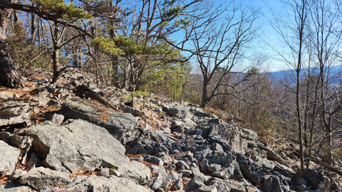
Day 3: Gap Creek Trail intersection to FR375 (approx. 13 miles). You’ll pass an excellent campsite at Big Run in about 5 miles, and you’ll want to get water there. Then you’ll make the steepest ascent of the trail with an 800-foot climb up Waterfall Mountain. (Spoiler alert: there is no waterfall.) You’ll pass campsites near the intersection with Crissman Hollow Road, and then you’ll make a U-turn and start heading northeast. At about 10 miles, you’ll reach Jawbone Gap, where you can descend on the Jawbone Gap Trail for water and a lovely campsite with a fire ring by a pond, but that will add a few miles for tomorrow. There are some unreliable water sources and established campsites between Jawbone Gap and FR375, and you’ll find a small, but pleasant campsite slightly uphill on your left 0.2 miles before FR375.
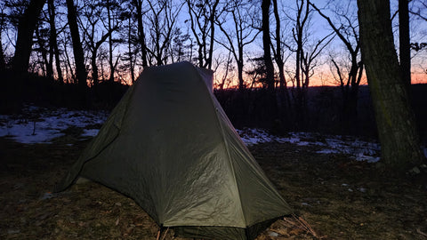
Day 4: FR375 to 7-Bar-None (approx. 12 miles). You’ll ascend the ridge for several rocky miles before descending to Edinburg Gap. Consider FR375, a lightly-used gravel road, as a much faster alternative, especially if you stayed at Jawbone Gap or if you want to push to Mine Gap today. There are OHV trails east of FR375, and you are likely to hear them in spring, summer, and fall. You will also find a small, somewhat trashy campground and pit toilets just before Edinburg Gap Road, and there is a spring below Waonaze Peak shortly after the road. Get water at the spring because you’ll be on the ridge for the next 13 miles, but note that it may be unreliable in dry weather. More OHV trails will be on your right as you stay on the ridge 4 ½ miles past the spring to a tiny campsite at the intersection with the 7-Bar-None trail, where I spent a shivery night in the teens this time last year. If you have the energy, or if you took the road, consider cruising another 6 ½ miles to Mine Gap, where you’ll find a spacious campsite.
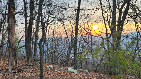
Day 5: 7-Bar None to Signal Knob (approx. 12 miles): stay on the dry ridge for 8 miles where you’ll briefly rejoin the Tuscarora Trail before descending to Mudhole Gap, where an excellent piped spring awaits to quench your thirst and provide water for yet another dry campsite tonight. You’ll pass an abandoned camp on the left and Strasburg Reservoir, a lovely little lake where I have never managed to catch even a single fish. Then you will ascend to Signal Knob where you can enjoy excellent 270-degree views to the west, north, and east on your last night out at a small established site near the overlook.

Day 6: Signal Knob to Signal Knob Parking (approx. 6 miles): Savor your morning views before beginning the descent. You’ll pass many campsites and enjoy some rocky sections of trail and more views as you pass the Fort Valley overlook and return to your car.
Permits and logistics: No permits are required for this trail in the George Washington National Forest, but check for burn bans in dry weather. There are several access points, including Elizabeth Furnace, Camp Roosevelt, Crissman Hollow, and Edinburg Gap, so it would be possible to cache water in dry weather or make a point-to-point trip. It is also possible to make shorter loops using connecting trails, especially the Gap Creek and Jawbone Gap trails. The Elizabeth Furnace campground has showers in season and would be a nice place to stay before or after hiking. Hunting is allowed in season, and fishing requires both a Virginia license and Forest Service permit. Wildlife includes deer, bobcats, snakes, and bears. A bear crashed through the brush past me on my last trip as it ran away from some hunters. I recommend using a Bear Vault canister for food storage because it is fast and simple to use, especially if you find yourself hiking until dusk, and it doubles as a stool to sit on. As always, check current conditions before you go, plan for bad weather, and let someone know your itinerary.
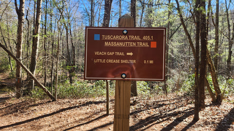
I want to save you from the navigational errors I made with the Tuscarora Trail signs. Follow the blazes rather than the arrows, which generally indicate features that are not on the Tuscarora Trail. If there is no arrow for the listed destination, continue straight. For example, to stay on the Tuscarora/Massanutten Trail to Little Crease shelter at the intersection shown below, ignore the arrow pointing to the right and follow the blazes straight.
For more information:
George Washington National Forest
Trail Description from The Trek
Signal Knob Trail Description from Hiking Upward. They have descriptions of other parts of the trail, too.
You can see my videos of the trail:
A 60-mile loop on the northern part of the trail in March 2023.
A 32-mile loop on the southern end of the Massanutten Trail in Dec 2023.
And of course you can stop by the store if you have any questions, because I would love to talk to you about this trail!